Wind and rain bridge
Hong Bridge Audio Guide (Hongqiao)
A red stone bridge from 1670, older than the walled city itself, which was market, road and market again over the Tuo River, and which popular memory says was raised to cut a dragon's neck.
- 30 min of audio
- Qing dynasty
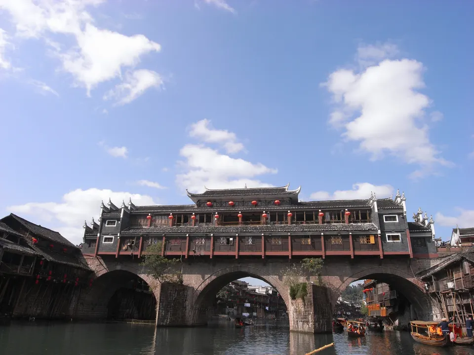
The present stone bridge was built in 1670, the 9th year of the Kangxi emperor, under the name Reclining Rainbow Bridge, and in 1914 it was remodelled and renamed Hongqiao, Rainbow Bridge. Two boat-hull piers and three arches of local red stone blocks carry a two-storey timber pavilion in the manner of the Dong people's wind and rain bridges. Below, a covered walkway between shops; above, a folk culture hall with calligraphy and paintings devoted to the bridge itself.
Its life has been one of comings and goings. On the deck, 12 timber houses once stood on each side, with eateries and bazaars; in 1955 all of them were taken down to make way for cars, and only works begun at the end of 1999 gave the shops back to both sides. In July 2014 the Tuo rose above any known mark and the bridge faced the hardest test in its history. And in Fenghuang they say it was not built just to cross the river, but to close the city's road to the throne.
Highlights
- Three red stone arches — The 1670 bridge on two piers sharpened like boat hulls against the current
- Covered central walkway — Shops on both sides, heirs of the 12 houses per side of the old bridge
- Wind and Rain Pavilion — Two-storey timber in the manner of Dong bridges, lit at night over the Tuo
- Upper-floor hall — Calligraphy and paintings devoted to the bridge itself, with views over the river
- East Gate tower — The entrance to the city wall, right ahead as you step off the bridge
In the old town of Fenghuang, where the Tuo River separates two banks of stilt houses, a red stone bridge acts as the hinge between them: the Hong Bridge (虹桥, Hongqiao). Its present form dates from 1670, the 9th year of the Qing Kangxi emperor, when it was raised under the name Reclining Rainbow Bridge (Wohong Qiao). In 1914, the third year of the Republic, a remodelling gave it the name it bears today, Hongqiao, Rainbow Bridge. The surprising part is that the bridge is older than the city around it: Fenghuang, a garrison frontier town, began to be built in 1704, 34 years later.
The history of the Hong Bridge also has a disputed date. One line of sources stays with 1670; another, following tradition, places a first bridge at this crossing of the Tuo in the early years of the Ming Hongwu era, from 1368, raised for propitiatory purposes, and gives it some 600 years. The two versions could coexist if there was a Ming crossing before the Qing stone bridge, but no open source documents it. Nor is there agreement on the reconstruction of 1999-2000: for some it gave the bridge back its original look; for others it was a substantial rebuild, and it is unclear how much of the old appearance has been recovered.
The architecture of the Hong Bridge reads in layers. At the bottom, the oldest part: two boat-hull piers and three arches of local red stone blocks. Above, a two-storey timber pavilion with stacked roofs, which follows the model of the wind and rain bridges of the Dong people and is lit at night over the water. On the ground floor runs a pedestrian walkway between shops and bazaars; on the upper floor, a folk culture hall gathers calligraphy and paintings devoted to the bridge itself.
To know what to see at the Hong Bridge, the audio guide covers it in four stops and 30 minutes: first from the north bank, facing the arches; then along its covered walkway; and finally before the tower of the wall’s East Gate, which appears right ahead on crossing. The thread is a single one: a bridge that was market, road and market again, that withstood the greatest recorded flood of the Tuo and that, according to popular memory, was raised to cut Fenghuang’s destiny short.
A hundred metres downstream, the Wanshou Palace lines up its three doors with the bridge’s arches; very close are the Yang Family Ancestral Hall, tucked against the wall, and the North Gate Tower, with its stone stepping stones over the Tuo.
Two stone prows against the Tuo
Three red stone arches
Summary of this stop
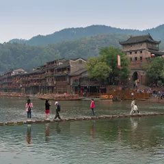
From the north bank, the bridge shows itself whole, in two materials. Below, three stone eyes of reddish blocks, resting on two piers that sink into the water; above, the dark timber of the pavilion. The stone is the oldest part of the whole, the 1670 bridge that the Kangxi reign christened Reclining Rainbow Bridge, built of red stone from the area.
The most ingenious detail is at water level. The two piers are not rectangular: they are shaped like boat hulls, sharpened like prows toward the current, a profile that reduces the Tuo’s push against the bridge. It is river engineering designed for a river that does not always run as gently as it seems.
In July 2014 those prows sat their hardest exam. After days of torrential rain, at three in the afternoon of 15 July the Tuo reached a level of 307.06 metres at the Fenghuang station, 1.16 metres above the historic maximum; the water rose to 1.5 metres at the lowest points of the old town, the city lost power and some 110,000 people, tourists included, were evacuated. Upstream, in Jinshuizhai, the flood swept away a covered timber bridge. On 26 July the old town reopened to visitors. Facing the arches, the narration tells how the Hong Bridge held out against that flood.
A covered market over the river
Hong Bridge
Summary of this stop
At the north entrance, the bridge stops being a crossing and becomes a street. A covered pedestrian walkway runs between two rows of shops and stalls, and the first impression may be of a set designed for tourism. It is not: it is the old form of the bridge.
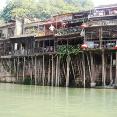
On the original deck stood 12 timber stilt houses on each side, with eateries and bazaar shops, separated by a central walkway 2 metres wide. A roof covered that walkway and sheltered it from wind and rain, and that is where its second name comes from: Fengyu Lou, the Wind and Rain Pavilion. On the nearby banks, two-storey timber houses on stilts still stand, dropping to the water, of the same type as those that once occupied the bridge.
The model is that of the wind and rain bridges of the Dong people, here turned into a market: over the water, people ate and shopped. As night falls, the pavilion lights up over the Tuo. At the entrance to the walkway, the audio guide explains what it meant to eat and shop in the middle of a river.
From market to road, and back
Central walkway of the pavilion
Summary of this stop
In the middle of the covered walkway, what draws attention is what is missing: no vehicle crosses the bridge today. And yet for almost half a century that is exactly what it was, a road. In 1955 all the timber constructions on the deck were taken down and the Hong Bridge became a bridge for traffic.
The return came at the end of 1999, with a year of works that rebuilt the bridge’s houses and gave the shops back to both sides. The present pavilion has two floors: the lower one of shops and bazaars; the upper one a folk culture hall with calligraphy and paintings devoted to the bridge itself and views over the river. Along the way, the bridge had already changed its name once, when the 1914 remodelling turned it into Hongqiao.
What one walks on today is at once memory and reconstruction, and not all sources agree on how much of the old appearance has been recovered. In the heart of the walkway, the narration reconstructs the three lives of the bridge.
A city younger than its bridge
East Gate of Fenghuang
Summary of this stop
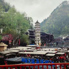
On stepping off the bridge, the tower of the wall’s East Gate appears right ahead and marks the entrance to the walled enclosure. At the start of the Qing dynasty, Fenghuang was a garrison frontier town with “six thousand inhabitants and eight thousand soldiers”. The walled city was built from 1704, the 43rd year of Kangxi: 34 years after the stone bridge already crossed the Tuo.
Before that gate, popular memory gives the bridge a far darker role. The legend says that the first Ming emperor, Zhu Yuanzhang, heeded a geomancer who had followed a dragon vein from the Kunlun mountains, across the Yunnan-Guizhou plateau, to the old fortress of Wuzhai. Mount Nanhua, south of the city, and the peak that plunges into the Tuo would be the dragon’s head: a sign that someone able to contest the throne would one day come from here.
The people of Fenghuang, much given to feng shui, say the emperor prevented it with a stroke of his vermilion brush, ordering the dragon’s neck to be cut, and that this cut is the bridge. Beside the East Gate tower, the audio guide’s last stop tells what Fenghuang lost, according to the legend, when the bridge was laid.